Canada’s wildfire season of 2023 was nothing short of unprecedented.
Contributing to its severity was an early snowmelt and ongoing drought in many (though not all) regions amid the warmest summer on record, globally. Hot, dry, and windy weather dominated in many regions, bringing a relentless season of fire from early May through late September, as fuels were primed for intense burning. Numerous records were set, including overall area burned (roughly 5% of all forest area in Canada – an area larger than New Brunswick and the island of Newfoundland combined), the number of pyrocumulonimbus events observed across the country, the number of wildfire evacuees, and duration of wildfire smoke in many locations across the west.
Canada 2023 wildfire perimeters. Credit: ARCGIS
Canada wasn’t the only place to experience intense wildfire activity during the summer months. Greece, Italy, Portugal, Spain, and Maui were among other locations with devastating wildfires that impacted many communities, leading to destruction and loss of life.
Canada Wildfire Season 2023 Stats
The following data are provisional and based off the latest information from ECCC and NRC:
Total number of wildfires: 6703 (CIFFC, 12/29) Total area burned: 18.49 million hectares (CIFFC, 12/29) – based on satellite hotspots Percent lightning-caused: 59%, accounting for 93% of area burned International wildfire crew members: 5000, from 12 nations Total number of evacuees: Over 240,000 (record, since 1980) PyroCb events: 142 (David Peterson/USNRL)
Records were also set in numerous locations for duration of wildfire smoke in “smoke hours” (10km or less visibility, typically from May 1-Sept 30, as observed by a human):
Fort Smith: 1263 (1319 including October) Fort Simpson: 920 La Ronge: 893 Yellowknife: 829 (832 including October) Peace River: 743 Calgary: 512 Saskatoon: 321 Edmonton: 299 Regina: 263
Unfortunately, 4 wildland firefighters perished during the season, with two more fatalities being indirectly tied to the wildfires.
Notable Events
May 5:
A significant outbreak of wildfires occurred across much of Alberta, driven by strong, dry southeasterly winds – a setup typical of other past disastrous wildfire events in the province occurring during spring dip.
We documented a large wildfire burning southeast of Edson.
Credit: CIRA
Highly-tilted smoke columns above EWF-031
June 3:
A number of lightning strikes occurred across Quebec on June 1 that resulted in an incredible outbreak of wildfires that all seemingly popped up on June 3. Here, there had been no ongoing drought – only favourable fire weather.
The smoke would go on to darken skies and cause horrific air quality for millions down the eastern half of North America.
Lightning fires pop up across Quebec on June 3. Credit: CIRA.
The fires continue to rage, creating a massive plume of smoke that would blanket eastern Canada and US. Credit: CIRA.
Smoke blankets New York. Credit: CIRA.
September 22:
The most significant single day burn occurred on September 22, with hotspot estimates of near 700,000 hectares burning in portions of BC, AB, and NT. In an event that bore strikingly resemblance to the 1950 Chinchaga firestorm, in terms of timing, magnitude, and downstream effects.
Wildfires take off on Sept 22 across NE and NW AB. Credit: CIRA.
The smoke plume traveling across Canada from Sept 22-27th. Credit NASA.
Large amounts of smoke lofted high into the troposphere would get rapidly carried to the northeast, darkening skies over Nuuk, Greenland on the morning of the 25th, and leading to reports of purple suns in Nova Scotia and the UK on the 27th and 28th.
The optical effect of the sun’s disc appearing lavender or blue is the result of a very high density of particles of uniform size that come to be after several days of fallout, causing shorter wavelengths of visible light (blues and violets) to scatter more readily and become visible to our eyes.
Additionally, there were about 240,000 wildfire evacuees across the country, with the largest occurring in the Kelowna area (including both Kelowna and West Kelowna - the latter from which a higher number evacuated) and the entire city of Yellowknife - both on or around August 17th and 18th.
Wildfires approaching Yellowknife. Credit: NASA.
The McDougall Creek wildfire burns across Lake Okanagan from downtown Kelowna, BC.
Wildfire is a critical part of the health of the boreal forest landscape. However, current trends toward longer, warmer fire seasons with more lightning amid overcrowded forests that haven’t burned in a long time (or perhaps, that begin to burn too frequently without fully recovering) will invariably lead to more intense wildfires that could be at times detrimental to forest health.
2024 will bear watching – at least in the beginning, as ongoing drought across much of Canada, combined with warm, dry conditions through this winter, could set the stage for a troublesome start to the 2024 season. Current conditions are trending similarly to the spring of 2016, which preceded the Fort McMurray wildfire – the costliest disaster in Canadian history.
Ongoing drought across much of Canada. Credit: North American Drought Monitor.
I have officially made my first foray into high altitude ballooning!
With the help of Nick Janzen and other friends, I have been able to partake in two launches so far. I produced a short documentary on the first adventure for The Weather Network:
May 7th, 2022:
For both launches, we launched from Nick's property in Carbon, Alberta, outside controlled airspace. Regardless, we had NOTAMs issued for both flights.
Inside my homemade payload box, I had Nick's APRS radio transmitter, two GoPro cameras (a GoPro Session 5 pointing upwards, and a GoPro Max facing outwards), a 25800mAh battery bank as a backup for the cameras, and a SPOT device for backup GPS tracking. We used a 3-foot parachute by Spherachutes, and attached another micro-tracker to the flight train.
We inflated a 1200g latex meteorological balloon (from Hoskin Scientific) with H2 gas, and released the 1550g payload around 1015AM. According to local forecast soundings, the minimum temperature reached was likely -52C. We'll have actual instruments on board for future launches.
The balloon reached a maximum altitude of 104,100 feet, before landing 71km NE of the launch site near Big Valley almost 3 hours later, or 4 miles west of Caprona on RR205. Watch the documentary for details on the entire journey, which was a nail-biter at times!
Trajectory of the May 7th flight.
It was mind-blowing to see the GoPro footage from my first flight!
May 15, 2022:
I used a different payload box for this flight, so I could use my GoPro Max for the upward shot in the hopes of capturing the moment of burst. Turns out it worked yet again, and for a second time, the camera survived the entire journey on backup power from the battery bank. Both times, the bank (along with SPOT device) had a hand warmer taped to it.
We put the APRS tracker in a separate box this time, but it didn't work for the majority of the flight - likely due to an antenna issue. The micro-tracker worked until shortly after the balloon burst, at which time the violent swinging motion caused the webbing attaching it to its carabiner to fail. The tracker then plummeted straight to Earth and stopped working.
We launched around 945AM and the flight lasted about 2.5 hours, reaching minimum temperatures below -60C (per forecast sounding) owing to a higher tropopause.
For the second time, the SPOT device worked perfectly and led us directly to the landing location, which was in an expansive tract of native grassland about 103km ESE of Carbon, or 3 miles north of Sunnynook on the west side of the road.
The 600g balloon (from Hoskin Scientific) towing a 1650g payload reached a stunningly high maximum altitude of 92,900 feet before bursting.
Distance between launch and landing, with a similar trajectory.
The cirrus gave nice texture for this launch
A quick look back at most of the flight train before the blue tracker ripped off
The weather balloon peeling at the moment of burst!
October 1, 2022
Darren's first launch!
My third HAB mission brought lots more learning, on a fun (but stressful) day with most of the original launch team and my friend Darren.
Our mission was to capture the sunset at or above 80,000 feet, so based on all parameters, we decided on a launch time of 550PM MDT. Sunset was at 710PM, and for every 1.5km of altitude above the Earth, we get one more minute of daylight. At altitude, this was 15-20 minutes later than sunset on the ground, and we wanted about 15 more minutes of ascent after the disc of the sun disappeared below the horizon.
We used a 1200g Totex balloon, obtained from Hoskin Scientific. My payload as is typically runs about 1kg, which includes my Spot device, a GoPro Max, a battery bank, a couple of hand warmers, and the styrofoam box with harness. We typically add some other experimental radio tracking devices to the flight train, as we did in this case, ending up with a payload weight of 1585g. One could justify using a 42" chute for this weight (per Spherachute's descent rate chart), but we opted for the 36" chute once again (as we did on May 7th). We used hydrogen as a lifting gas.
Northeasterly upper level winds were present to the NW of an upper low, so the trajectory was actually toward Calgary. At the surface, we had a breeze on the order of 10 knots from the south, so we needed all the help we had for handling the balloon while filling. Such a breeze on a large balloon also likely gave the impression that we had amply filled the balloon to lift our counterweight off the ground, but it quickly became apparent based on a 2.65m/s ascent rate out of Carbon that we had under-filled the balloon by a large margin. We accepted that this meant a much longer flight time was likely, and we'd miss our target of documenting the sunset at high levels. Based on the habhub calculator, our balloon was forecast to burst 3h38min after launch, at 932PM. We launched at 554PM. It was then forecast to land just NE of Calgary, which made us quite nervous.
Real time, the balloon actually ended up right over NE Calgary at about 50Kft, before drifting SE and going offline. Our radio tracker had frozen and stopped transmitting, and my Spot device sent its last ping for a while at 742PM. Based on this fact, we estimated (based on a truncated descent trajectory, assuming a much faster descent) that the balloon should land somewhere near Chestermere. We headed to Chestermere BP's, thinking our balloon would burst and come back online sometime after 930PM, but upon arrival, my Spot device had sent two pings over Scenic Acres and then NE of Springbank Airport, so we assumed it was already on descent (possibly due to the radio tracker separating from the flight train, causing the ascent speed to increase, leading to an earlier burst). We jumped in the cars and drove west.
However, perplexed, the Spot device once again stopped transmitting (after 852PM and 902PM). We looked around near some private property in Springbank before resolving to give up and resume the search during daylight. Feeling dejected, I had come to the conclusion the payload sustained severe damage or landed in an area the GPS would not work. Then, we got another ping, this time near Chestermere, where we'd originally thought it would land. We blasted back across Calgary and looked at the location where the ping was, but found nothing. Then, we received more pings well to the east, so while there was some relief from knowing the Spot device was still alive, we figured there must be some kind of electromagnetic interference causing all the wildly different locations around southern Alberta. All of this was operating under the assumption the balloon must have burst by then, and that GPS devices do not transmit above 60,000 feet.
We opted to call it for the night, and hope the GPS would sort itself out by morning, pinging a location more than once. It then occurred to us that a significant, M8.8 solar flare likely disrupted our GPS device right in the middle of the flight. It peaked at 822PM MDT, which likely explains the blackout between 742PM and 852PM as the balloon was over Calgary.
In the morning, I woke up and checked my Spot device. The last pin I had seen was south of Strathmore at 1239PM, and initially while looking at the map I saw no new pins, so my heart sank as I had believed the payload was lost. However, upon closer inspection, I noticed that there were actually a pile (over 50) pins at the spot south of Strathmore. The Spot was 3 for 3 - we had found the landing location of the payload. Thankfully, the its receiver hadn't been nuked by the solar flare - but will be considering solar activity for launches going forward, via solarham.net.
17 hours after turning on the Spot, and after sending it up in a box to temperatures near -60C for several hours, it was still functioning. Those Energizer lithiums, which I replace before every flight, are great! My camera card had filled up after 5h20min, which included 4h57min of flight time, meaning it was recording until 1051PM. Based on the clear view of the Calgary/Airdrie/Okotoks lights from well to the east, the balloon was still rising at this time, which, given a roughly constant ascent rate of 2.65m/s (159m/min), would mean the balloon was rising through 47223m AGL. I received pins at 1052PM and 1102PM, before receiving one to the southwest at 1132PM. I believe the balloon burst between 1100-1115PM due to the position of the pins relative to upper level winds, which we looked at after the fact.
It turns out that due to an unexpected ascent to such high altitudes (above the level of forecast soundings and stuck within the parameters of the calculator, that assumed the (Kaymont) balloon envelope would fail at 35km) meant the trajectory would be much different. On raw GFS data, we found that a strong westerly jet existed above 130Kft, which explains the rapid eastward motion prior to burst as it ascended to near 50,000m (164Kft). This is a ridiculously high altitude that can only be inferred and sadly not confirmed by tracker data, but it is consistent with the fact the newer Totex balloons seem to over-perform (which may also be due to under-filling). It is also consistent with the trajectory, which was amazingly (though spottily) being transmitted well above 60Kft by my Spot device.
Given the position of the 1132PM pin, the balloon was on descent at an unknown altitude, before hooking NW on southerly/southeasterly low level winds, coming to rest at its landing location. It wasn't until 1239AM that we began receiving pings from its landing site in a field south of Strathmore. The payload was undamaged, and the backup battery bank still had 2/3 power (GoPro still full power, though 128G SD card full). This is something to keep in mind. The Spot Device works awesome (using fresh lithiums, with a hand-warmer - unknown to what extent this helps), transmits spotty locations above 60Kft, and may take a while to begin transmitting once on the ground.
Next few flights we want to nail the sunset, and try shooting video at 4K resolution - both during the day, and at night. I had opted for 1080p/60fps because of the turbulent motion of the box in the wind, so I could slow down the footage to being smooth. It works well for this purpose in this setting - but is a poor low light performer.
Landing site, after a flight that lasted well over 5 hours.
The view from about 50Kft, not long after sunset. Looking south toward the moon, with Belt of Venus to the E/SE, a thick layer of haze, and the city of Calgary below.
While great sunrises and sunsets can happen anywhere, the Canadian Prairies seem to have a high frequency of truly spectacular events in a given year. This is particularly true in the Chinook Country of southwestern Alberta. Whether it's a morning Chinook Arch with illuminated tendrils of virga, the upwind edge of a Chinook Arch at sunset, or evening mammatus after a storm, there's no shortage of banger events treating delighted locals.
All scenes above were shot on my smartphone in 2021.
9. Southern Alberta Grassfire, then Dust Storm
On March 28th, a strong downslope wind event brought wind gusts in excess of 100km/h along the Highway 2 corridor south of Calgary, igniting a grassfire that would rapidly burn a swath of dry farmland as well as several structures east of Claresholm.
Burn scar and dust storm seen from space. Satellite image courtesy Sentinel
Torched fenceposts amid blowing topsoil
On April 1, another downslope wind event created a significant local dust storm within and east of the burn scar, liberating tonnes of topsoil.
On April 17, we observed numerous dust devils over the locally-low albedo surface of the burn scar during the warm, dry, and windless afternoon. Nearby, we observed an absolutely massive dust devil that formed on an alkali lake bed.
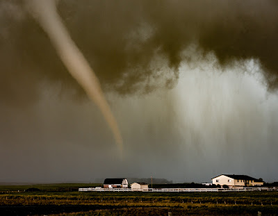
8. High River Area Tornadoes
Tornadogenesis
Maturity
On June 5th, we observed a pair of tornadoes south of Calgary. The first occurred near Longview, and the second, pictured above, occurred just southwest of Blackie. The latter had "Lawnmower Man" vibes, as indeed, it developed in a similar environment - but thankfully resulted in no damage or injuries despite crossing over a major secondary highway. It's always encouraging to nail your storm chasing target a day or two in advance.
A number of other large gustnadoes and dust devils occurred in the area as well, with steep low level lapse rates owing to a dry surface, along with the presence of a wind shift boundary in the area. I wrote more about this event here.
7. Amazing Aurora Event
During the early morning of November 4th, an incredible, long duration Aurora event occurred, bringing dazzling pillars of green, purple and red to the skies within the Auroral Oval. What was really notable in the Calgary area was the dancing corona overhead, as the lights flickered and swayed vigorously for several hours after midnight.
Other really good Aurora events occurred on March 20th and April 16th. As we head into the next solar maximum that peaks in July 2025, there will undoubtedly be more stunning displays ahead.
6. Cold Weather Experiments
Without fail, my best-performing content in a given year is always related to the extreme cold, and the shenanigans we get up to in it.
Additionally, I opportunistically shot video of me karate kicking rime ice off of chainlink fences and ball diamonds in southeast Calgary on January 24th.
5. Knocked Over by Wind
On January 19th, I climbed up to the summit of Nakiska Ridgetop for a second time to document the wind. I had been practicing my pattern recognition to see what kind weather conditions lead to maximum wind gusts, so I went out when I figured I had found my weather window. As I was up there, I encountered a 193km/h gust - far stronger than the previous year's 124km/h gust.
I learned that I couldn't stand when gusts exceeded about 170-180km/h, and learned that I'll need knee and elbow pads next time for getting knocked down onto the hard scree. I had to crawl a fair ways down the upper ridge because it was simply too hard to stand. That's one way to feel humbled by nature and get the adrenaline dumping!
4. Transport Truck Tips Over
On January 12th, a strong downslope wind event in southern Alberta resulted in a number of transport trucks tipping over along highways 2 and 22 south of Calgary in typical fashion. These roadways run perpendicular to the terrain, and thus, the crosswinds that roar down the slopes of the front range and foothills. Any trucker caught off guard with a light load owing to a sudden gust - especially when banking away from the wind in the southbound lanes - can find their world suddenly going sideways.
On June 29th, Lytton broke Canada's all-time national high temperature record for the third day straight, at 49.6C. The heat was stifling, making it hard to work outside for long, and causing my camera gear to rapidly overheat. The air smelled strongly of cooked sagebrush and juniper, and your feet would burn through the soles of your shoes on the hot pavement. Lytton is often BC's hotspot, so that felt like the safe place to target for experiencing maximum heat.
Initially, the mood was lighthearted, as I was attempting to fry and melt things on a cast-iron pan on the street in the scorching heat. Little did I know that the next day the village would be gone. I wrote at length about the experience here.
2. BC Firestorms
Pyrocumulonimbus cloud near Savona on June 29th
The same day that Lytton broke the all-time record high, a number of large, human-caused wildfires rapidly took off. Heading back toward Kamloops, I saw a gigantic pyrocumulonimbus cloud blowing up over the Sparks Lake fire near Savona.
The following day (June 30th), the firestorm raged on, with numerous, powerful cloud to ground lightning strikes being generated by the plume several kilometres north of the fire, which sparked more wildfires. There's something about documenting wildfires that is uniquely intense and stressful. Here are some more visuals from the area on the day that Lytton burned down nearby, and a more in-depth look at the event.
1. The Sun is Blotted Out of the Afternoon Sky
BC's fire season was just relentless, so I found myself back in the interior providing live coverage in mid-August after the whole city of Vernon was put on evacuation alert ahead of the nearby White Rock Lake fire. It was more personal for me this time as well, as I have family in the city.
On August 15th, the thick, combined plumes of the White Rock Lake and Tremont Creek wildfires blotted out the afternoon sun along Highway 97 northwest of Vernon. It was here that I shot the most intense Facebook Live of my life to date.
2021 was really hard for a lot of folks - and not just because of the weather. It has been a very challenging year for me personally, and I have been taking the time to self-care and get the help I need.
On a brighter note, I was able to document 8 out of Alberta's 12 species of owl in 2021. I drove thousands of kilometres, and didn't manage many very good photos, but my love of these elusive creatures grows more every year. I am excited to see how I'll do in 2022!
Owls of 2021:
- Snowy Owl
- Great Grey Owl
- Great Horned Owl
- Northern Pygmy Owl
- Northern Saw Whet Owl
- Boreal Owl* (very rare)
- Short-eared Owl (favourite)
- Northern Hawk Owl
Missing:
- Barred Owl
- Long-eared Owl
- Eastern Screech Owl (rare)
- Burrowing Owl* (very rare)
Robert, the Downy Woodpecker
I've also had up to eight species of bird eat from my hand in Calgary this fall. These include Black-capped Chickadees, Boreal Chickadees, Mountain Chickadees, Red-breasted Nuthatches, White-breasted Nuthatches, and Rock Pigeons. I am most excited about the Downy Woodpeckers and Black-billed Magpies, though!
On December 15, an incredible lenticular stack occurred atop a standing wave east of Centre Peak in southwest Alberta. Wintertime along the foothills of Alberta can be an interesting time for watching clouds associated with Chinooks and downslope windstorms.
Earlier in the year, timelapse imagery revealed the impressive motion of a violently tumbling rotor cloud, as snow was being lofted off front range peaks by winds gusting over 160km/h.
Screengrab of above linked video.
9. Central Alberta Ice Jams
Ice Jam on the Little Red Deer River, west of Bowden
Very cold conditions through late winter led to very thick ice coverage on rivers across Alberta. Then, a sudden spring thaw led to rapid melt of snow cover that flowed into rivers as runoff, leading to rapid breakup of the ice. This ice then jammed up near prominent bends in the rivers, at times letting loose and bulldozing over adjacent banks. Major flooding occurred in the city of Fort McMurray, and the River Creek RV Park near Stettler was destroyed by thick river ice.
8. Alberta Wild Ice
The above bubbles form at Abraham Lake every year, resulting from decaying organic matter on the bottom of the lake that give off methane bubbles that become frozen into the ice. Alberta has plenty of wild ice, but this is some of the most stunning.
High in the Alberta alpine, retreating ice sheets also lead to some caves near the toe of the glaciers. These areas can be difficult and technical to access, but they're truly stunning.
7. Southwest Alberta Windstorm
I went up to document the winds on Nakiska Ridgetop for my first time on January 31st, where one of the windiest ECCC weather stations in the country exists. I only observed a gust of 124km/h this time (I say "only" because 200km/h+ gusts can occur at times), but it was still an intense experience, as daylight waned in the huge, inhospitable mountain environment.
After descending the mountain and receiving a flurry of anxious texts from friends and family who were waiting to hear from me, I drove south of Calgary late that evening with my friend Darren, where we documented severe winds into the early morning hours of February 1. We had 140km/h gusts near Granum, with trucks tipping over along the typical stretch of Highway 2. Turns out I didn't need to climb a mountain to experience high winds!
6. June 13th Monster Thunderstorms
Supercell near Vauxall
June 12-13th brought back-to-back days of intense thunderstorms to southern Alberta, as a large scale negatively-tilted trough pivoted out of the western US. An earlier, similar setup also occurred a couple of weeks earlier that also brought severe weather. It had been a wet spring, so there was plenty of moisture available for severe storms.
On June 13th, we watched as several attempts at severe storms popped near the US border south of Lethbridge, until a dominant storm tracked NNE out of the Montana foothills and just west of Highway 36 through southern Alberta, into rich low level moisture throughout the evening hours. It produced a tornado south of Taber (only a single weak one, somewhat surprisingly), softball-sized hail NW of Brooks, and intense lightning. Meanwhile, that evening, the costliest hailstorm in Canadian history would pummel northeast Calgary with wind-driven tennis ball-sized hail, resulting in losses of $1.2B.
The period from late September through the second week of October brought one of the best displays of fall colours to southern Alberta in recent memory. A wet summer had given way to long, clear, and cool nights in early fall that would lead to vibrant yellows in larch and aspen poplar around southwestern Alberta.
It was particularly wonderful in the Rockies, with numerous clear mornings over our famous glass-like lakes.
4. Mountain Thunderstorm
It is a rare treat to see a sculpted thunderstorm in the mountains, but that's what we saw on the evening of July 31st. A strong, slow-moving thunderstorm clung to the front range of the Rockies west of Calgary, sinking south-eastward throughout the evening. When it reached some locally-enhanced storm-relative inflow at Morley Flats, the storm intensified and dropped tennis ball-sized hail along the Trans-Canada Highway.
We dropped south on Highway 40, and watched the wonderfully-illuminated western edge of the storm from behind, as clear skies to the west helped to prolong the sunset. We even saw a grizzly foraging in the ditch along the road. A memorable evening with Darren and Poi Yee, indeed!
3. Calgary Supercell
On July 23rd, we hung back near Calgary based on a favourable real-time environment for severe weather - despite the more well-advertised target to the north, which was struggling with cloud cover issues. Severe storms erupted just west of the city in the early afternoon, with the dominant storm tracking right over the city. A tornado warning was issued, as we saw a large funnel just west of Signal Hill, which brought some intense moments as we observed the storm from the side of a busy Glenmore Trail in the southwest.
After a frustrating escape through the city, we watched as the storm churned with impressive rotation over Calgary and eastward across southern Alberta through the evening, along with two other supercells.
2. Frozen Pants Make the Tonight Show
In my second winter of doing cold weather experiments, we tried to freeze some clothes to play around with, among other things. We proceeded to smack the clothes on a brick wall and throw them around like frisbees, all while filming it. A couple of mornings later we found out it made it onto the Tonight Show. I can now say I've made Jimmy Fallon laugh!
1. May 30-31 Thunderstorm Madness
Ample moisture following a wet spring and powerful upper disturbance from the southwest led to several rounds of intense thunderstorms in southern Alberta between May 30-31st.
First, I observed intense cloud-to-ground lightning in the Banff area during the evening, which lit up the surrounding snowy mountainsides in a rather exciting spectacle. I then headed back toward Calgary, when intense lightning began dropping all around Cochrane during the late evening. We went home and waited for the overnight round, which brought hundreds of lightning strikes to areas south of Calgary. The storm then rolled into downtown Calgary, where I captured a strike hitting the Calgary Tower at about 330AM. I was very excited about this, but decided I should probably try to get a couple of hours of sleep ahead of another big chase day.
About 12 hours later, we documented a tornado at close range southeast of Irricana. Darren and I could see flash condensation whirling over the ground about the base of the condensed funnel, and could hear the tornado as well. It crossed the road about 50 yards in front of me, before going out across a lake as it began to rope out.
Bonus:
And for a moment of wildlife magic, I witnessed a Snowy Owl hork up a pellet east of Calgary in late November. It had consumed several meadow voles, and I know this because I went back the next day to get the pellet intent on dissecting it. It wasn't the first time I saw an owl regurgitate in front of me, either!